Hiking Mount Pelée: Complete Tourist Guide to Martinique's UNESCO Volcano
On the morning of May 8, 1902, a cloud of superheated gas, ash, and volcanic rock traveling at over 160 kilometers per hour swept down the southern flank of Mount Pelée and obliterated the city of Saint-Pierre in under two minutes. Approximately 30,000 people died—15% of Martinique's entire population—making it the deadliest volcanic eruption of the 20th century and one of the most catastrophic in recorded history. The eruption was so distinctive in character that volcanologists named an entirely new eruption type after it: a Pelean eruption, defined by its lethal pyroclastic flows.
Today, Mount Pelée rises to 1,397 meters above that same coastline, designated a UNESCO World Heritage Site in September 2023 for its globally significant volcanic geology and the extraordinary biodiversity of its protected forest. It is one of the most rewarding and genuinely challenging hikes in the entire Caribbean—a trail that takes you through cloud forest, over a volcanic caldera, and to a summit with views across Martinique and out to Dominica, Saint Lucia, and the Pitons on clear days.
This is how to do it properly.
Why UNESCO Listed It in 2023
The UNESCO World Heritage designation covers "Volcanoes and Forests of Mount Pelée and the Pitons of Northern Martinique"—a combined site that recognizes both the extraordinary geological significance of Mount Pelée's Pelean eruption type and the exceptional biodiversity of its surrounding tropical forest.
"The volcano is not just a dramatic natural feature—it's the defining reference point for an entire category of volcanic science."
Mount Pelée is considered scientifically unique because Pelean eruptions—characterized by lethal pyroclastic density currents (nuée ardente, or "fiery cloud") rather than lava flows—were not understood or classified before 1902. The 1902 event fundamentally changed volcanology as a discipline, introducing concepts of pyroclastic flow dynamics and volcanic hazard assessment that are still central to the field.
The forest reserve surrounding the peak supports over 1,300 plant species, 50% of Martinique's endemic flora, rare tree ferns more than 15 meters tall, endemic amphibians including the Martinique Volcano Frog (Allobates chalcopis), and a cloud forest ecosystem that has no parallel elsewhere in the Caribbean.
The Three Trails: Choosing Your Route
Mount Pelée has three official hiking routes, each approaching the summit from a different direction, offering genuinely different landscapes, difficulty levels, and experiences.
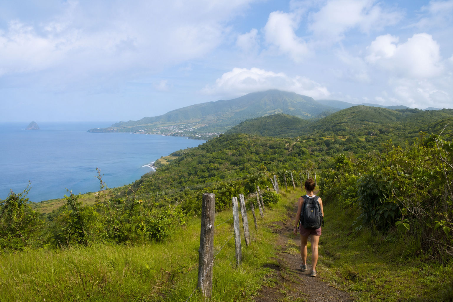
Trail 1: L'Aileron Trail (ONF Trail #23) — The Classic Route
Distance: 7.5km round trip
Duration: 3 hours to the second refuge; 5.5 hours for the full summit loop including the caldera walk
Total elevation gain: approximately 700m from trailhead (900m of total elevation change accounting for ups and downs along the ridge)
Difficulty: Challenging; rated 8 out of 10 by experienced Caribbean guides
Trailhead: L'Aileron car park, end of the D39 road off the N3, approximately 820 meters above sea level near Morne-Rouge
The Aileron Trail is the most popular and most accessible route up Mount Pelée—described by Martinique's official tourism board as the "lowest difficulty" of the three options, which should not mislead anyone into treating it as easy. It is consistently described by hikers as steep, slippery, and technical in its upper sections.
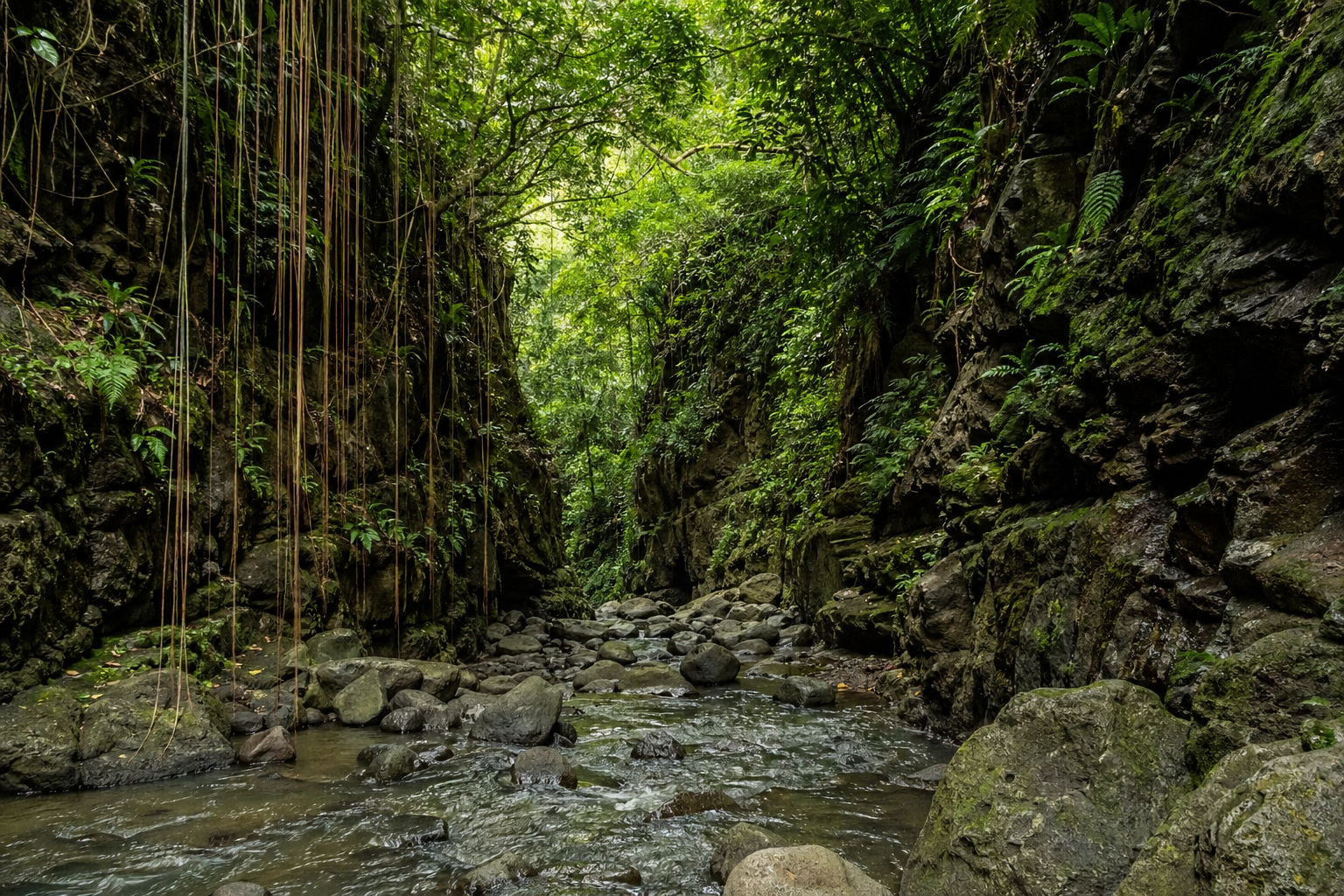
The trail begins at the small car park and first refuge shelter at 820 meters and climbs steadily through montane cloud forest—dense, humid, and extraordinarily lush in the lower sections, gradually becoming more exposed as you gain altitude. The mid-section crosses a series of rolling ridges with views opening eastward across the northern Martinique hills.
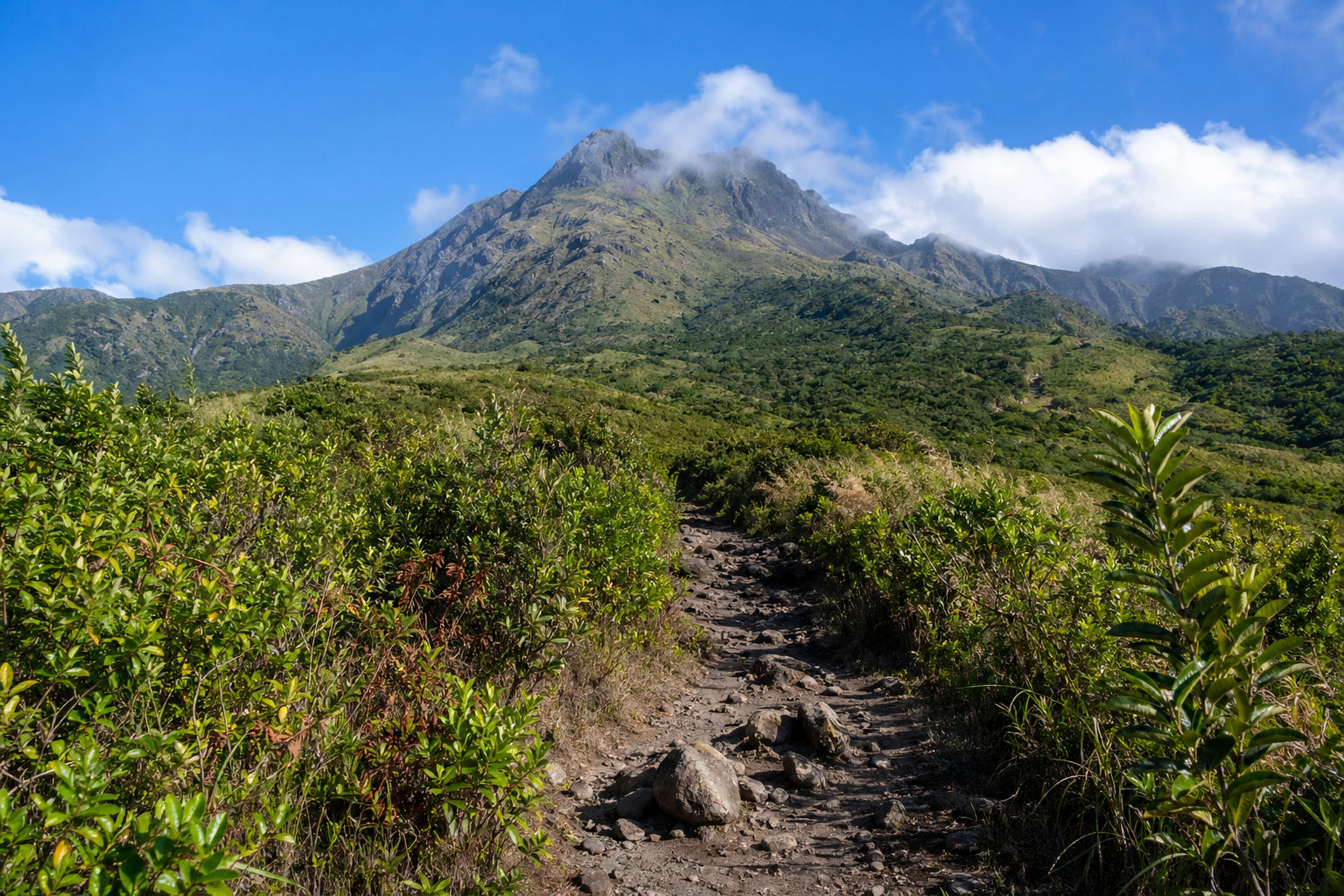
The upper section is the most demanding: the trail hits a deep gorge that requires a descent and re-ascent, followed by a steep rocky scramble to the second refuge shelter at approximately 1,200 meters. From the second refuge, a spur trail continues to Le Chinois—the highest accessible peak at 1,397 meters—and a separate loop path circles the edge of the main caldera, the remnant of the 1902 crater.
"The caldera is the climax of the hike."
Walking its rim above the volcanic crater, looking into the depression that contained the force that killed 30,000 people, with the Caribbean stretching out below on all sides, is one of the most viscerally powerful landscape experiences in the whole region. On clear days—which require an early start—you can see Dominica to the south, Saint Lucia, and the twin Pitons rising from the sea.
Trail 2: La Grande Savane Route (ONF Trail #19) — The Caribbean Coast Approach
Distance: Approximately 8km to the summit from Le Prêcheur
Duration: 4 hours to Le Chinois without caldera loop; 5 hours with
Total elevation gain: 680 meters
Difficulty: Moderate to challenging
Trailhead: Le Prêcheur village, Caribbean coast
The Grande Savane route is the only trail approaching Mount Pelée from the Caribbean (western) side, and it delivers a completely different landscape from the Aileron Trail. The western slope is rain-shadowed by the volcano itself and consequently drier, more open, and more exposed to sun—the trail passes through savanna-like volcanic scrubland before entering the upper forest zones near the summit.
"The dramatic difference in vegetation between the humid eastern approach (Aileron) and the drier western approach (Grande Savane) reflects the volcano's influence on its own microclimate."
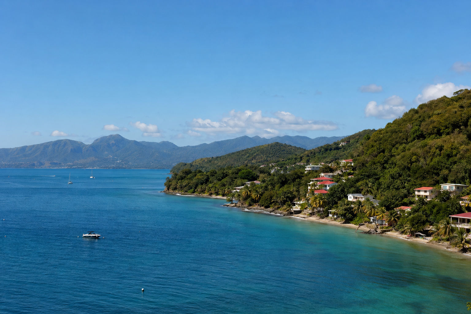
Starting from Le Prêcheur also puts you in the context of the 1902 catastrophe before you begin climbing—the village itself was heavily damaged by the eruption, and the ruined coastline and the rebuilt church carry visible reminders of the event that made this volcano famous.
Trail 3: Le Grand Rivière Route (ONF Trail #21) — The Epic Challenge
Distance: 17km
Duration: 8-10 hours
Total elevation gain: 1,300 meters
Difficulty: Very difficult; for experienced and fit hikers only
Trailhead: Grand Rivière village, northern tip of Martinique
The Grand Rivière route is the longest, most demanding, and most remote trail on Mount Pelée. Starting from the island's northernmost village—accessible only by a road that ends at the sea—it climbs 1,300 meters to the summit through the densest and most pristine section of the UNESCO forest reserve before descending via the Aileron route to Morne-Rouge.
This is a genuine mountain expedition that requires a full day, a guide, pre-arranged transport logistics between the two trailheads, and a high level of physical fitness. The rewards are proportional: you walk through forest ecosystems that most visitors to Martinique never see, at altitudes that put you above the cloud layer in the early morning with the island's highest peaks rising above the mist.
The 1902 Eruption: Understanding What You're Standing On
No visit to Mount Pelée carries its full meaning without understanding what happened in May 1902, and the story is one of the most extraordinary in the history of natural disasters.
Mount Pelée had shown signs of reawakening from early 1902—fumaroles increasing, light earthquakes, ash falls beginning in late April. By May 3rd, phreatomagmatic activity was well underway and ash was falling on Saint-Pierre, the colony's most important port city and cultural capital, 10 kilometers south of the summit.
Crucially, colonial authorities and local officials consistently reassured residents that the danger would pass. Governor Louis Mouttet and his wife stayed in Saint-Pierre as an act of public confidence. Elections were scheduled for May 11 and officials were concerned that mass evacuation would affect the vote. Refugees from the surrounding countryside had actually streamed into Saint-Pierre, increasing the population at risk.
On the night of May 7-8, activity intensified dramatically. At 7:52am on May 8, a massive explosion launched a pyroclastic density current—the nuée ardente—directly southward down the volcano's flank at devastating speed. The cloud of superheated gas and ash reached approximately 700°C and moved fast enough to reach Saint-Pierre in under two minutes. Every building was destroyed. Ships in the harbor were capsized and burned.
"Of approximately 30,000 people in Saint-Pierre that morning, there were two survivors on land—the most famous of whom was Ludger Sylbaris."
Today, the ruins of Saint-Pierre—including the old theatre, the former jail cell where Sylbaris survived, and the remains of ships on the harbor floor—are among the most historically significant and emotionally resonant sites in the Caribbean. Visiting Saint-Pierre before hiking the volcano adds a layer of weight and meaning to the summit experience that turns a great hike into something genuinely unforgettable.
Saint-Pierre: The Essential Pre- or Post-Hike Visit
Saint-Pierre has been rebuilt into a small, atmospheric town that retains its ruins alongside its modern life—uniquely in the Caribbean, destroyed walls and vine-covered foundations coexist with cafes, restaurants, and a working harbor. Key sites:
- The Ruins of the Theatre — Saint-Pierre was known as the Paris of the Caribbean and its theatre hosted European performers; the grand facade and the collapsed interior remain visible and accessible
- The Jail Cell of Sylbaris — the thick stone cell below ground level that protected the one land survivor; a small, sobering space that makes the scale of the disaster viscerally real
- The Franck A. Perret Museum (Musée Vulcanologique) — established in 1932 by American volcanologist Frank Perret who studied the eruption; contains melted church bells, fused bottles, twisted iron, and artifacts preserved since 1902 that function as a visceral record of the pyroclastic flow's temperature and force
- The Underwater Wrecks — 14 ships sunk in the harbor on May 8 now form one of the Caribbean's most famous wreck dive sites; boats and dive operators depart from Saint-Pierre's small harbor offering beginner-friendly wreck snorkeling and full scuba diving on several of the wrecks at various depths
Practical Information: Everything You Need Before You Go
What to Bring
The mountain's weather is unpredictable and the terrain is demanding:
- Water: minimum 2 liters per person; 3 liters recommended for the full summit loop; no water sources on trail
- Footwear: proper hiking boots with ankle support and good grip; the trail is rocky, root-covered, and extremely muddy in the cloud forest sections; trail runners are acceptable; road shoes are genuinely dangerous
- Rain jacket: clouds form quickly at altitude and the upper sections can drop temperature suddenly; a lightweight waterproof is essential
- Sun protection: the Grande Savane route and exposed upper ridge sections have no shade; factor 50 sunscreen, hat, and UV clothing
- Snacks and food: no facilities on any trail; bring sufficient calories for the duration
- Trekking poles: strongly recommended for the descent; the trail is steep and slippery after any rain
When to Start
Begin no later than 6:30-7am for the Aileron Trail. The summit is clear in the early morning and clouds close in from approximately 10am. Starting at 7am gives you a realistic window of clear summit views before the cloud arrives. Starting at 9am means a high probability of reaching the caldera in cloud.
Do You Need a Guide?
The Aileron Trail and Grande Savane routes are navigable without a guide for experienced and fit hikers with trail navigation experience. The trail is marked, and the ONF (Office National des Forêts) maintains the routes. However:
- A guide is strongly recommended for first-time visitors to the mountain
- The Grand Rivière route requires a guide for logistics and safety
- In misty or rainy conditions, route-finding on the upper sections becomes significantly more difficult
- Local guides add the historical and geological context that transforms the hike from a physical challenge into a genuinely educational experience
Licensed guides are available through Martinique's Office du Tourisme and through Fort-de-France-based tour operators.
Getting to the Aileron Trailhead
The Aileron trailhead is approximately 60 kilometers from Fort-de-France via the N3 highway, turning north at Le Morne-Rouge. The drive takes around 1.5 hours. Rental car is the most practical option. If driving at 6:30am departure, leave Fort-de-France by 5:00am.
Parking: A small car park is available at the trailhead. It fills quickly on weekends; arrive early.
Endemic Wildlife and Forest Life
The UNESCO listing specifically recognizes the biodiversity value of Mount Pelée's forest reserve, and hiking through it gives you a genuine nature encounter beyond the geological drama:
- Martinique Volcano Frog (Allobates chalcopis) — endemic to the volcanic slopes; found in the cloud forest sections of the Aileron trail; a small, brown, globally threatened species that exists nowhere else on earth
- Tree ferns — ancient, towering specimens reaching 15 meters in height in the humid cloud forest; visually extraordinary and prehistoric in character
- Martinique oriole (Icterus bonana) — an endemic bird found only on Martinique; reliably present in the forest sections of the lower Aileron trail
- Balisier (Heliconia caribaea) — Martinique's national flower, with dramatic red and yellow bracts common along the lower trail margins
- Trembler (Ramphocinclus brachyurus) — an endemic bird that shakes its wings continuously as it moves; common in the mid-elevation forest
The Pitons of Northern Martinique: The Other Half of the UNESCO Site
The UNESCO designation covers not just Mount Pelée but also the Pitons du Nord—a chain of older, eroded volcanic peaks running along Martinique's northern coastline including Morne Macouba, Morne Pierreux, and Piton Mont Conil. These peaks offer additional hiking for visitors staying more than a day in the north.
The Le Prêcheur to Grand Rivière coastal trail—one of Martinique's most dramatic hikes entirely independent of the volcano—traverses the cliffs and lava coastlines between these two northern villages with views back toward Mount Pelée throughout. It's only accessible by boat at certain points (the coastal cliffs are impassable on foot) and requires advance planning, but for serious hikers it's the finest full-day walk on the island.
FAQ
Is the Mount Pelée hike suitable for beginners?
No, not the full summit route. The Aileron Trail is described as the "least difficult" of the three routes but is still rated 8 out of 10 by experienced Caribbean guides. It involves 700+ meters of elevation gain on rocky, slippery, root-covered trail with a deep gorge crossing. Good fitness, proper footwear, and an early start are non-negotiable. Beginners should consider a guided half-day hike to the second refuge (3 hours) rather than pushing to the summit.
How long does it take to hike Mount Pelée?
The Aileron Trail round trip to the second refuge takes approximately 3 hours; the full summit loop including the caldera walk takes 5-5.5 hours. Allow 6-7 hours total including stops and the drive.
What time should I start the hike?
6:30-7am at the latest. Clouds form from approximately 10am and regularly close the summit entirely by midday. An early start is the single most important factor in getting clear views from the caldera.
Is Mount Pelée still active?
Yes. Mount Pelée is an active volcano and is monitored continuously by the Martinique Volcanological Observatory (OVSM). Minor activity occurred in 1929. As of 2026, the volcano remains at normal background activity levels and trails are fully open.
When did Mount Pelée become a UNESCO World Heritage Site?
September 17, 2023, as part of the site "Volcanoes and Forests of Mount Pelée and the Pitons of Northern Martinique".
How many people died in the 1902 eruption?
Approximately 28,000 to 30,000 people, representing around 15% of Martinique's total population at the time. The single surviving land resident was Ludger Sylbaris, a prisoner whose underground cell protected him from the pyroclastic flow.
Do I need a guide to hike Mount Pelée?
A guide is strongly recommended but not legally required for the Aileron and Grande Savane routes. The Grand Rivière route effectively requires a guide for logistics and safety. Guides add significant historical and geological context and are particularly valuable for first-time visitors.
The Summit Is Worth Every Step
Mount Pelée is not an easy hike. The trail is steep, the terrain is demanding, and the weather at the summit is never guaranteed. But standing on the rim of the caldera that launched the deadliest volcanic eruption of the 20th century—looking down into the crater, looking out to Dominica and Saint Lucia in the distance, surrounded by a cloud forest that exists nowhere else on earth—puts you in a small and privileged group of travelers who discover that Martinique is far more than its beaches. The UNESCO designation in 2023 confirmed what every serious hiker already knew: this is one of the genuinely great natural experiences in the Caribbean, and it is waiting for every traveler willing to start walking before sunrise.
Explore more Caribbean island travel guides on IsleRush, or read our Martinique destination guide for everything else the island offers.